Skip to main content
You are here
Cornwall Collection
Pages
-
-
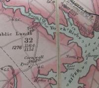
1852 Map
-
This is only a small section of the map. This map was the result of a survey conducted by H.W. Bayfield. It was created by Surveyor General George Wright Esq. in 1852. H.J. Cundall, L.S. made further additions and corrections in 1874. Interesting to note is the dark dotted line along the Tryon Road (TransCanada Highway) the line signified electric telegraph lines. The Post Offices (P.O.) in Cornwall and North River, the grist mill (*G), the Methodist Wesleyan Church (Wes.) are also marked on the map. Perhaps most interesting is "Pye's". Obviously at this time, the name of community (Cornwall) had been established, but "Pye's" was still marked. Records do indicate that John Pye ran a tavern, perhaps this tavern was the landmark of the community. Some older residents of Cornwall still refer to the TransCanada Highway/Meadow Bank Road/Cornwall Road intersection as Pye's Corner.
-

-
1863 Lake Map
-
This is a small portion of the 1863 topographical map of Prince Edward Island published by W.E. Baker
-

-
1880 Meecham Atlas
-
This is a portion of Lot 32 of Meacham's 1880 Atlas. Lot 32 can be found on page 90 of the 1973 Commemorative Edition of the Atlas
-
-
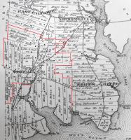
1882 School Boundary Map
-
The red boundary lines were added to Meacham's 1880 Atlas using the Paint program according the to the boundaries described in 1882.
"Cornwall School District No. 39 in Queens Co. is defined as follows: That is to say beginning at Enoch Drake’s east line and running thence north along said line to his north line thence west line along said line to rear of Malcolm Murchison’s land, northward along said rear to James Howards south line, east along said line to his east line, north along said line to north line west along said line to rear of D. Scott’s land, thence north in west lines of D. Scott and T.K. Mayhew to John Walker’s south west angle of land; thence east in J. Walker’s south line to Tryon Rd; thence by this road afore-said to Thomas Heartz south line, thence west along north line of John Conway’s land to road leading to East Wiltshire, thence north by said road to the line dividing the farms of Robert Frizzle and Samuel Howard; thence west in said line to west line of lot 32; thence south in said line to Richard Leonard’s north line, thence west to Mr. Leonard’s west line, thence south in said line to road leading to Clyde River; thence to John McQuarries west line, thence south his south line, thence eastwardly along north line to Joseph Hyde and Janes Drake and south line of P. Costello to Henry Drake’s west line, thence north to Henry Drake’s north line; thence east by the creek to F. Crosby’s east line; thence east to the creek and thence by the creek and share to the place of commencement.
Registered herein March 6, 1882"
(From PARO 2632/3)
-

-
1928 Cummins Map
-
This map is just a portion of Lot 32 from Cummins 1928 Atlas. Lot 32 is found on pages 60 and 61
-

-
4H
-
Cornwall 4H members showing cattle at the MacMillan property. Just visible in the background are two children on a 1952 Studebaker belonging to Lance Lowther's family.
-

-
4H
-
Cornwall 4H members showing cattle. From left to right are; Donna Wilson, Jeannie (MacMillan) Doucette, Lance Lowther, Gail (Lowther) Stewart
-

-
Aerial North River
-
This photograph hangs in the Cornwall Town Hall. It is an aerial view of North River taken c. 1959. Clearly visible in the top right hand corner is the North River rink. To the left (east) of the rink is the former North River hall, left (east) of that is the Shell Service Station. Just north of the rink where the road forms a fork is a brown pitched roof building. This was Ramsay's General Store. The road on which Ramsay's store was located is now called Lakeview Drive. This road was also led to the North River bridge. The fields North of Lakeview Drive are now occupied by Chateau Estates.
-

-
Alice's Diner
-
This diner was owned by Alice Wilson (left). It was one of the first in Cornwall.
-

-
Audio: Beechwood Gardens
-
Cornwall, at one time was very well known for the Beechwood Gardens which were operated by Mrs. Gordon MacMillan. This description of the Gardens was provided by Lawson Drake
Pages